Monday, April 02, 2007

Geography of the Pacific

A recent Roper Public Affairs poll painted a dismal picture of the geographic knowledge of the most recent graduates of the American education system. Nine out of ten could not find Afghanistan on a map of the Middle East, and six in ten could not find Iraq. It's not just the outside world apparently, fewer than half could identify the state of New York. I like to think part of this is due to an emphasis on teaching social studies for the purpose of creating an understanding of the concepts behind events, rather than merely the memorization facts. But the fact remains - we suck at geography. Here's a very basic look at the geography of the pacific.

The Pacific islands are generally divided into three distinct geographic groups: Melanesia, Micronesia, and Polynesia.

Melanesia
stretches from Indonesia in the west, through the islands of New Guinea, the Solomons, Vanuatu, New Caledonia, to Fiji in the east. Melanesia is derived from the French ‘Melanesie’ meaning ‘black islands’ and is in reference to the darker skins of the inhabitants of these islands. The term was first applied to the region by a French scientific voyage in the 1830's.

Micronesia means ‘small islands’, and lies in the central western Pacific. Its most significant groups are the Palau, Carolines, Marshalls, Marianas and Gilbert islands.

Polynesia meaning ‘many islands’, stretches from Samoa and Tonga in the west, across to Easter Island on the far eastern side of the Pacific, and south to New Zealand. It includes, the Hawaiian Islands, Tahiti, the Marquesas, and the Cook Islands.
-------
Although these groupings are ethnic as well as geographic entities, it is important to note that the division is a Western idea. There is more cultural exchange between these groups, as well as diversity within them, than this simple division might imply.

Sunday, April 01, 2007

Human Migration: into the pacific


When European explorers first ventured into the Pacific Ocean they were surprised to find that even some of the most remote islands were already occupied by thriving societies. The existence of these Pacific people provided them with a mystery which has in some ways persisted to this day. How had a people who lacked any physical navigational instruments or even metals, preceded them into the Pacific by thousands of years? Thinkers of the time suggested that they must be the remnants of some simple people, blown of course by chance or dragged there by currents. If you look at the space allotted to Pacific people in history curriculum around the world today, I'm afraid you would probably find a similar story, if you found them at all. I set out to find a little more about the people of the Pacific, specifically a part of the answer to the question of how they got there. What I found out was that far from a chance occurrence, the peopling of the Pacific was a result of a giant technological leap, one that represented a massive change in the pattern of human migration. Our story of human migration begins less than 100,000 years ago, when homo sapiens, the ancestors of all modern humankind, evolved in Africa and began to move into Central Asia. Some headed West into Europe and others traveled around the perimeter of India and into Southeast Asia, eventually making their way into the archipelagos of Malaysia, Indonesia, New Guinea, and even Australia. All of this progress was made in small stretches over thousands of generations. It was also done on foot or in simple rafts that could only make very short journeys.
These early humans were able to make it all the way to Australia because in the last ice age water trapped in the polar ice caps lowered sea levels. The Indonesian islands were actually joined to Eurasia. New Guinea, Australia and Tasmania were also all joined in one land mass, which was far more accessible from Southeast Asia. Today we find evidence that people reached Australia as early as 40,000 years ago, but there progress was checked there. No other large land masses would be reached by humans for another 20,000 years.

The next major event in human migration occurred when people crossed a similar land-bridge connecting Asia to the Americas, along the Berring strait. There is some debate over whether this was a result of hunters following game on land or traveling along the coast in small crafts, or both. In either case it didn't represent a shift in technology, and the places on earth that required a true ocean passage, like the Pacific islands, remained devoid of human life.

Around ten thousand years ago, with the end of the ice age, sea levels rose again, isolating the archipelagos of the Philippines, Indonesia and New Guinea. Australia became detached from New Guinea and Tasmania, and these populations remained relatively isolated for thousands of years. Still, the Pacific and its countless islands remained beyond human reach.

Then around 6,000 years ago, for the first time in human history, a people escaped the confines of landmasses that could only be reached by foot or simple craft. They pushed of from the mainland of South East Asia and and made their way eastward into the Pacific and a world where no human had proceeded them. Eventually they reached as far east as Easter Island, likely the coast of south America, and astonishingly as far west as Madagascar.

The accounts of their individual journeys are not recorded in journals or captains logs as they were in later European voyages of discovery, but this does not detract from their achievements in terms of the seamanship that they required. These voyages spanned more than half the globe and took place at a time when Europeans had not ventured beyond the Mediterranian or the coast of their continent.

What made these first voyages possible was the invention of the sail and the "outrigger", an extension which stabilized their dugout canoes.
However, as the gaps between islands grew from tens of miles at the edge of the western Pacific to hundreds of miles along the way to Polynesia, and then to thousands of miles in the case of voyages to Hawaii and the Eastern Pacific, these oceanic colonizers developed huge double-hulled vessels, capable of carrying large groups, as well as all the supplies they would require to colonize new lands.

For long voyages such as these Pacific peoples used a large double-hulled canoe made of two large canoes connected by lashed crossbeams. The two hulls gave the craft stability, and the central platform laid over the crossbeams provided the needed working, living, and storage space. Large sails made of matting allowed it to move swiftly through the seas, and long steering paddles enabled Pacific mariners to keep it sailing on course. A medium-size voyaging canoe, 50 to 60 feet long, could accommodate two dozen people for a month long voyage.

As they moved farther and farther away from the familiar flora and fauna of Southeast Asia and New Guinea, they also had to develop a portable agricultural system which would enable them to survive in the nutrient low environments they would encounter. Ethno-botonists today have determined that these early Pacific mariners must have travelend in intentional colonizing parties, bringing Pigs, dogs, rats, and fowls, as well as cultivated plants such as bananas, breadfruit, taro, yam, gourds, and sugar cane, into the Pacific Islands. All of these made ecosystems of the pacific livable, and turned them into the "natural paradise" that Europeans would encounter centuries later.

Recently computer simulations have also suggested that because of prevailing winds and currents, many of the inhabited islands of the pacific could only have been reached as a result of careful and intentional voyages of exploration. When looked at in conjuncture with the highly sophisticated systems of navigation still practiced in some parts of the Pacific, it becomes clear that these trips were deliberate colonizations. Armed only with a knowledge of the movements of the stars, the ability to read the signs from the ocean itself, the flight patterns of birds and other natural signs, the people of the pacific set out to explore and settle the most widespread and far removed regions of the earth.


This is an image of the earth taken from space. From this perspective you can really get the magnatude of the Pacific Ocean and an appreciation for the people who first explored it.

It's worth mentioning that the famous captain Cook, who mapped and explored so much of the pacific ocean for the European world, did so with a native Tahitian navigator on board. He and his officers made efforts to learn the Tahitian language, so that they would be able to communicate with Tupaia, who accompanied them for their voyage through the Pacific, and all the way back to England. From his diary it is clear that Cook was amazed by the polynesians ability to travel between distant points and across empty seas. He described Polynesia as "by far the most extensive nation upon earth."


New Zealand: Land Before Time

About 130 million years ago, in the mid-to-late Jurassic period, the land that today comprises New Zealand was torn away from the southern supercontinent of Gondwana.

Because this split occurred prior to the evolution of marsupials and other mammals, and because New Zealand was so far removed from other land masses, it meant that throughout nearly its entire existence New Zealand would be devoid of mammalian life.

Other than a native bat, which presumably somehow flew here in geologically recent times, and sea mammals such as seals, New Zealand has gone through it's evolutionary past in relative isolation form the rest of the world and with out the impact that the advance of mammals has had elsewhere. As a result New Zealand has one of the worlds most unique ecosystems. In fact about 80% of the flora and fauna in New Zealand occurs only in New Zealand and no where else.


FORESTS

A walk through New Zealand's remaining native forests is in some ways like a real life "Jurassic park", and gives some indication of what the world was like millions of years ago. The progenitors of New Zealand's forests stemmed from Gondwana and its existing species have developed in relative isolation from the changes that have occurred in forests elsewhere in the world. In some areas massive kauri trees with diameters of over twelve feet wide still scrape the sky. Much of the forest is filled with the dense foliage of strange tree ferns that look to those who are not used to them like overgrown house plants.


BIRD LIFE

In the absence of mammals, birds came to occupy a dominant role in New Zealand's ecosystem. Up until just a few hundred years ago the largest herbivore in the New Zealand's forests was the moa, a giant flightless bird which reached 12 feet in height and weighed up to 550 pounds. Prior to human contact the Moa's only predator was the Hasst's eagle, the largest predatory bird to have lived, with a wing span of up to ten feet.

Today New Zealand's bird life remains exotic, with ground dwelling parrots, kiwis and other flightless birds. I found it particularly strange to be in an alpine environment in which snow occurs year round and at the same time being surrounded by group of Keas, large parrots that have adapted to living in the mountains.


--------------------------------------------------

New Zealand's exotic flora and fauna are a major draw
for foreign travellers, however, the fact that these creatures have had no inherited defences against human predation, or against the other animals which humans introduced into their environment, has made them especially vulnerable. Both the Moa and the Hasst's eagle's extinctions are attributed to hunting and forest clearance by the Polynesian ancestors of the Maori, who for several hundred years shared New Zealand's environment with these giant birds. Only recently has the devastation that the impact of European settlers and the animals that they introduced have had on New Zealand's ecosystem begun to be understood. Today, travellers that arrive to New Zealand by airplane are run through a rigorous search and screening process. Having your bags run through a machine and searched is something we are all getting used to, but in New Zealand their primary focus is not drugs or terrorist threats, it's invasive species. My tent was quarantined until they could determine that the tiny grass seeds that they detected were not a potentially threat to native species.

Wednesday, March 07, 2007

Village Visit

Wanting to get a closer look at village life in Fiji and an idea of what life was like prior to European contact, I made the necessary preparations for a trip out to the island of Nacula, one of the furthest in the island chain of the Yasawas group. I stopped off at several islands along the way and made friends with a German traveler name Henrick, who agreed to make the journey all the way to Nacula with me. For the last leg of the trip we had a local fisherman drop us off at a tiny cove on the southern edge of Nacula, and he pointed us to a trail that would presumably lead us towards the village itself.


The path took us over the spine of the island where only a tall grass grew, above which we could see the sweeping panoramas of this and other islands. After some distance the path dipped down into a valley and we began to see signs of farming, planted rows of sweet potato, banana and bread-fruit trees.


Then, through some foliage and into a sunny clearing we could make out a number of thatch-roofed homes and wonderfully colorful laundry hung out to dry. It was deftly quiet, and though we had been anticipating it, Hendrick and I found ourselves at a a loss as to how to make first contact with the village and its inhabitants.

For some time we just stood there and I had just begun to suspect that no one was around, when from out of one of the huts came a joyous voice which proclaimed - Bula! There was no mistaking its meaning of welcome, and we replied with the same. A woman emerged with a flower print dress and instructed us in awkward English that before we are allowed to visit the village we must first meet its chief. We soon found ourselves following her lead down the narrow footpaths that meandered between the fifty or so identical homes. By each dwelling we were met with the same greeting and families gathered at their open doors and windows and smiled out at us as we passed.

The Meeting House

At the other end of the village there was a slightly larger structure built of the same materials as the others, which we were invited to enter and then asked to sit on the many reed mats that were spread across the floor. This we were told was the village meeting house. The woman who we had followed asked us to wait here for the chief and instructed us that when he came we should make a sevusevu, a small customary gift. Fortunately we were prepared and I had with me a small amount of kava which I understood was the traditional gift on such occasions.
Kava bundle at market

After a while the chief entered and sat cross-legged before us on the floor. He was a robust middle-aged man in a t-shirt, but he still maintained some degree regalregality. He graciously accepted our gift of Kava, which I presented by putting on the floor in front of him. Henrick and I introduced ourselves, and he invited us to look around at the many pictures of him and his family that adorned the walls of the meeting house. In one was his brother who we learned was a captain of a large ship and could be seen posing in his uniform. In another there was a few of his nephews proudly displaying a rugby trophy. Our meeting with the chief was brief. At its end he said that he would appoint his niece as our guide for as long as we chose to stay in the village and he introduced the young girl that had been waiting at the entrance, then he left.

I looked up at what appeared to be a large bone or tusk hanging from one of the rafters of the meeting house. When I asked our new guide about it, she explained that this was the Tabua, or the tooth of a sperm whale. In Fiji they are presented to important guests and exchanged at weddings, births, and funerals she explained. The particular tabua hanging in this meeting house was very old and showed that it had been worn by the many times it had changed hands.

We soon found out that our new guide, though shy, spoke a fair amount of English. She attended a boarding school on one of the "closer islands", Mondays through Fridays, at which half of her instruction was in English.


We followed her out and began our stroll through the rest of the village. On the way we passed what we were told was the home of the "oldest man" in the village. He was half way up a tree nailing something down when we met him. He was pretty limber for an old-timer. I shook his outstretched hand and he gave me a broad toothless smile, and said Bula of course. I told him that I was a history teacher, here to study Fiji's history. I asked if a lot had changed since he was a child in the village. He got what I had asked, and through our guide who translated he said
"When I was little we would cut the bananas before they were ripe. It would take us over a week to sail our small boats to the mainland. The bananas would ripen along the way and be ready by the time we made it to the market. Now we wait until they are ripe before we cut them and we use an outboard motor."

So, that pretty much sums that up.

Our next stop was the "store" which was really just a couple of shelves in a corner of one of the village huts. To see how little was actually available for purchase in the village drove home just how self sufficient it really was. Only a few staples such as tea, sugar, and flour were imported from the mainland. The rest of life's necessities were either fished from the sea, plucked from a tree, or were harvested in their village's gardens. This village apparently planted only three crops - sweet potato, pineapple, and bananas, and none of these required much looking after.

The church was by far the biggest structure in the village, but was still quite small. It was made of concrete, with windows along its side which opened to let in the sea breeze. Outside sitting under the shade of some marvelous trees, the likes of which I have never seen before, there was a group of women who, hearing of our arrival, had laid out their wares on blankets for us to survey. Our guide explained that these women make jewelery and such out of shells, which they sell to the boatmen who bring the goods to their village store, who in turn sell it to the shops on the mainland. They seemed eager to skip the middle man in this case, but it was still a remarkably low pressure sale. I purchased a large nautilus shell.


Near the coast at one end of the village there was a group of young men busy around a bunch of materials sprawled out on the ground. To my excitement I found out that they were constructing one of the village homes which I learned was called a bure. They were a fun bunch and were happy to let us investigate their progress. I brought out my video camera and one of the more gregarious guys gave me a full narration of the methods and materials involved in creating one of these traditional structures. It was pretty amazing to see it all come together. In what seemed like no time the framework was completed and they were explaining to me how the reeds were woven together and tied up to create the walls and ceiling.

The thing that I found really fascinating was what the villagers did with these homes when a hurricane struck. They told me that their traditional bures could be untied, disassembled and covered, keeping the materials protected. When it was over they would simply reassemble their bures. However, the newer construction that included boards, nails, and concrete would be torn apart and have to be completely rebuilt.

Like the rest of my experiences in this village, this got me to thinking about the merits of simplicity. Wandering around the village was an interesting look at life in a comparatively isolated corner of the world. There were of course signs of change everywhere. Several homes had electricity which was supplied from a generator. Some of the boats appeared to be made out of fiberglass. People had radios and other things bought from the mainland. But not much!


Trouble in Paradise

Gazing out the window on the short ride from the airport to my guest house in Nadi, I could see
the tropical beauty for which Fiji is so famous. In the distance were the great green peaks of the rugged interior and along the road were brightly colored homes on small plots with palm trees, and hibiscus and frangipani flowers blooming in their tiny yards. It was the spitting image of a holiday in paradise brochure. On the radio however, it was a different story. As my taxi driver and I careened around one beautiful vista after another, we listened in silence as a newscaster launched into a scathing rant about the inefficiency and negligence of the current interim government. For from without bias, it was absolutely merciless. It seemed that mud-slides during the recent rain had destroyed a number of villages on the north side of the main island, one of which had not received aid in three days. The newscaster made it abundantly clear that the blame was squarely on the incompetency of the current regime. After a good deal of this I turned to the driver and said something of the effect of "wow, that guy really has it in for the government" to which he replied, "yes, but of course here in Fiji we have a radio station for every persuasion."

He turned the dial, and after a few commercials, but right on cue, another newscast was releasing a statement that made it clear that the stranded village was a result of the previous regime's failure to modernize agriculture in the sector, and that the situation was further evidence of the type of mismanagement that made its removal necessary. It went on to describe the improvements that the current regime had already begun to implement in order to rectify the failures of their predecessors.

Not the kind of politicizing you would expect such a beautiful place to produce, but there was no chance that these mud-slides and the havoc that they the reeked could be left to blame on the rain alone.

In fact Fiji is no stranger to political instability - four coups in just 15 years have left their mark. The first took place at 10am on Thursday, May 14th, 1987, when Lt. Col. Sitiveni Rabuka (number three in the Fijian army), and 10 heavily armed soldiers dressed in fatigues, their faces covered in gas masks, entered the House of Parliament in Suva and forced the legislators inside to board army trucks at gunpoint. The resulting chaos has been a severe blow to the islands' economy and strained race relations in an ethnically divided society. Like most current events these coups have their origins in much more distant historical happenings.

Much of the political instability in Fiji has its routes in the ethnic tensions that exist there, and the foundations of a multiracial Fiji were laid in the late 19th century, when Fiji was a British colony. The first colonial governor of Fiji, Sir Arthur Gordon, introduced Indian indentured laborers to work on sugar cane plantations. Indians began arriving in 1879, and by 1916, when Indian immigration ended, there were already 63,000.


To come to Fiji, the Indians had to sign a labor contract or girmit, in which they agreed to cut sugarcane for their masters for five years. During the next five years they were to continue to work on the plantation, but they were allowed to lease small plots from the Fijians and plant their own cane or raise livestock. More than half of the Indians decided to remain after their contracts expired, and today their descendants make up the Indo-Fijian segment of Fiji's population.

In a rare example of good natured concern for its native subjects, the British decided to safeguard Fijian culture by prohibiting indigenous Fijians from commercial employment and protecting their land by law. The result was that Fijian land cold not be sold, only leased. To this day 83% of the land in Fiji is inalienable native Fijian land which can not be sold. Instead it is leased out in small plots, mostly to Indians. The effect has been that the Fijian chiefdom system has been largely maintained and the traditional Fijian way of life can still be seen throughout most of Fiji.

But this system, with its European capital, Fijian land, and Indian labor, has had its consequences. Fijian's have had little motivation to modernize, accumulate capitol, or invest in business. Instead they have been content to sit back and collect off of leased land. Indo-Fijians however, unable to purchase native protected land, have invested in their own businesses. Today it is estimated that less than 100 of the 5,000 businesses operating in Fiji are native Fijian owned. By 1946 the census held that Indians had already outnumbered native Fijians 120,000 to 17,000. Add to this the fact that Indo-Fijians pay nearly 80% of all taxes collected in Fiji, and their cries for equivalent political representation becomes obvious. Yet, the constitution has explicitly reserved the post of president, prime minister, and army chief for ethnic Fijians.

Prominent Fijian nationalists insist that Indo-Fijians must content themselves to be second-class citizens, or at least let indigenous Fijians run the country. They claim political leadership as a birthright by virtue of their status as the indigenous people of the country. They claim that any government in Fiji must legally safeguard native Fijian's position as the "taukei ne gele" or "owners of the soil." Even prior to the first coup in Fiji, at a rally protesting increased Indian participation in government, Apisai Tora, a prominent Fijian Nationalists, stated that Fijians must "act now" to avoid ending up as "deprived as Australia's aborigines."

It is an interesting historical and moral dilemma in Fiji. On the one hand you have an indigenous peoples' struggle to maintain sovereignty over their land. On the other hand you have victims of a racially discriminatory system, who, if left to legitimate representative democracy, could only expect to play a significant political role in the society.

Thursday, February 15, 2007

The Final Cut

During the first leg of my trip I shot over thirteen hours of footage. It's been among my most safeguarded possessions during my travels and has managed to survive at the bottom of my backpack in these special water-proof cases. For the brief time I have been home between legs of my trip I decided to set myself to the task of turning these tapes into something I can use in my classroom. Just labeling and cataloging it all took days. A lot of it I took with the intention of using it to illustrate specific historical events. It's from the inside of museums which allowed me to film in them, and from major historical sites like the Pyramids, the Taj Mahal, and the Eiffel Tower. With a little editing these segments will help me tell their stories to my students.
Other footage that I took is more random and does not fit so obviously into any single historical topic. I tried to make a habit out of taking out the camera every time I saw something that I thought my students might find interesting. The result is thousands of clips that provide small glimpses of every day life in the various countries I visited. Some of this turns out to be the most interesting stuff in my opinion. It has the potential to give my students a sense of the things that aren't noteworthy enough to make it into a chapter in their text book, but that illustrate the material and cultural differences that exist in their world. Through this footage I can take my students on a walk through the narrow alleys of Cairo, into a bustling train station in India, and on to an orphanage in Rwanda. Having shot the footage myself, I can answer any question they have about what they are seeing. Suddenly my students can feel they have interacted with parts of the world that they had not before. I place a lot of value on this kind of experience in the classroom. At a time when our actions and decisions are increasingly felt by people on the other side of the planet, I think it's essential that a world history course introduces students to what life is like for others around the world. It has certainly been my experience that it is harder to overlook world events that take place in parts of the world that I have been to. The old adage "out of sight, out of mind" has a flip side - once you have seen a place and interacted with its people it is hard to not care about them. A major goal for me is to try to use this footage to extend this sense to my students.

To edit I use a software called Final Cut Express HD. Basically the interface has four main windows: the Browser, where the original source media files that you capture from your camera are listed; the Viewer, where individual media files can be previewed and trimmed; the Timeline, where media can be brought together into a sequence; and the Canvas, where the edited production in the timeline can be viewed. Then of course there are a variety of filters that give your footage different looks and transitions to help connect clips in a way that is easy for the viewer to follow. It might sound complicated, but within a few days of when I installed the program I had four short film segments that were in roughly finished form. It's a lot of fun.

Saturday, January 20, 2007

Holy Sites of Jerusalem

Discussing anything remotely connected to religion with students can be risky territory for a teacher to tread, but to avoid a subject for this reason has dangerous consequences. To teach a unit on conflicts in the Middle East and not include the religious significance that people have attached to specific sites within the region gives students an incomplete picture. My students come from different backgrounds - some are Christians, Jews and Muslims who have inherited their own cultural perspectives on middle eastern issues. Most don't feel any connection to the people or land involved, and seem frustrated by this lack of understanding. They hear people talk about "crisis" in the middle east and they see it constantly on the news. Without an understanding of it, I see students resigned to the assumption that people in the middle east are simply prone to fighting, that the situation is a "stupid mess". While in Jerusalem, I set out to take a tour of these sites and try a straightforward historical approach to the religious significance that people have attached to them. My goal was to make myself better prepared to answer my students' questions about "what all the fighting is about over there".

The Temple Mount ר הַבַּיִת‎ "Har haBáyit"

The Temple Mount is an area of only thirty-five acres in the southwest corner of the old City of Jerusalem, but it is arguably the most contested real estate on earth. It has been the epicenter of the Jewish religion for almost three thousand years. According to classical Jewish belief, the temples that have been built on this site have been the primary resting place of God's presence in the physical world. Today all that remains of these temples is the mount or raised platform on which they were been built. The First Temple constructed by the Jews in the 10th century B.C.E was destroyed in 587 B.C.E by Nebuchadnezzar II of Babylon. The Second Temple was destroyed in 70 C.E By Titus of Rome. Lamenting the destruction of these temples is a central tenet of Judaism. According to Jewish scripture the mount is to be the site of the third and final temple, the rebuilding of which will signal the coming of the Messiah. Ever since the Second Temple's destruction, a prayer for the construction of the Third Temple has been a formal part of the thrice daily Jewish prayer services. Preventing Jews from carrying out the construction however, and a paramount source of contention between Jews and Muslims, is the existence of two of Islam's holiest structures that are built on top of the Temple Mount.

The Noble Sanctuary الحرم الشريف "Haram al-Sharif"
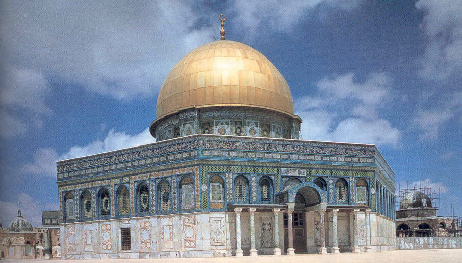
The same structure that is known as the Temple Mount by Jews is referred to by Muslims as "Haram al-Sharif" (The Noble Sanctuary). It is their third holiest site, proceeded in importance only by Mecca and Medina in modern Saudi Arabia. The primary reason for its significance to Muslims is the belief that Muhammad arrived here after a miraculous journey aboard the winged steed Buraq, and it was from this point that he ascended into heaven. For Muslims this is the place of Muhammad's last step in his religious journey before he met Allah and received the Islamic faith. Built on the site are two major Muslim religious shrines, "Qubbat as-Sakhra" قبة الصخرة (The Dome of the Rock) , and "Al-Aqsa Mosque" المسجد الأقصى (The Furthest Mosque).

The Dome of the Rock
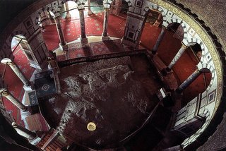
The Dome of the Rock was built in 691 C.E. by Caliph Abd al-Malik, half a century after the death of the Muslim Prophet Muhammad. It is the most visible structure in Jerusalem. It is not a mosque, but a shrine. Like the Ka'ba in Mecca, it is built over a sacred stone. This stone is believed to be the very place from which the Prophet Muhammad ascended into heaven during his Night Journey to heaven. It is the oldest Muslim building which has survived intact in its original form. It also boasts the oldest surviving mihrab (niche indicating the direction of Mecca) in the world.

Adding to the tension, according to Judaism this same stone is the site where Abraham fulfilled God's test to see if he would be willing to sacrifice his son Isaac (Muslims believe that this event involved Abraham's other son Ishmael and occurred in the desert of Mina where millions of Muslims offer pilgrimage every year). According to Jewish tradition, this was also the rock upon which the Ark of the Covenant was placed in the First Temple. During the existence of the Second Temple, the stone was used by High Priest who offered up incense and sprinkled the blood of sacrifices on it during the Yom Kippur Services. Rabbinic legend also alleges that the entire world was created from this stone, hence the name אבן השתייה, or Foundation Stone.

The Western Wall הכותל המערב "HaKotel HaMa'aravi"

A part of the Temple Mount known as the Western wall is regarded by many as the holiest location currently accessible to Jews. It is believed to be the last remnants of the fortifications of the second temple, and it is sometimes called "The Wailing wall", in reference to Jewish mourning over the destruction of their temple. Jewish men and women can be found praying at the wall at every hour of the day and night, though a "Mechitza," or divider, separates the men's section of the wall from the women's section. It is also a tradition to deposit a slip of paper with wishes or prayers on it into the cracks of the wall, and looking closely, one can see hundreds of tiny, folded papers left by visitors to the wall. Bar and Bat Mitzvahs are held here, and boys and girls of age travel from all over the world to have their ceremonies held by the Western Wall.


The Via Dolorosa
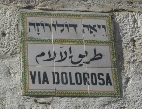
The Via Dolorosa (Latin for "way of grief") is traditionally believed to be the path that Jesus walked on the way to his Curcifixion. Along the path are nine of the fourteen Stations of the Cross, which each mark a site where an event occur ed in the final hours of Jesus' suffering. The last five stations are inside the Church of the Holy Sepulchre. At each site there is a small church or shrine and some kind of depiction of the event that occurred, such where Jesus collapsed, where he met his mother, where his face was wiped, and where he was stripped of his clothing. The object of the Stations is to help the faithful to make a spiritual pilgrimage of prayer to the chief scenes of Jesus' sufferings and death.


The Church of the Holy Sepulcher:
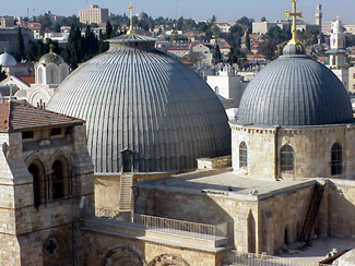
A "sepulcher" is a burial tomb, and the Holy Sepulcher derives its name from the Christian belief that it is the place where Jesus was buried and resurrected. Control of the church itself is as contested as Christianity is divided. Three major Christian denominations; Greek Orthodox, Latin and Armenian, control their own coveted turf inside and manage the church by consensus. Upkeep of the structure has been neglected due in large part to disagreements between sects over who has jurisdiction over what portions of the church. For instance, the ladder that can be seen at the window over the main entrance has been there since 1852, and has not been moved because it was present when the status quo was officially established and to do so would require the consent of each denomination. Interestingly, worries about Christian rivalries run so deep that a Palestinian Muslim family has had custody of one of the most coveted portions of the church for centuries - the keys.

At the entrance to the church is the stone of Unction or of Anointing. It is a polished red stone about six meters long and one meter wide. According to tradition it was here that the body of Jesus was anointed and prepared for burial. Christian Pilgrims come from around the world to kneel and pray before the stone.


In the center of a large rotunda lies the empty tomb of Christ or The Edicule. It was built around the remains of the excavated cave that Jesus was believed to be set in before he was resurrected. The interior of the Edicule is lined with marble and decorated with pictures, hangings, lamps and candelabra, which are numerically divided between the different Christians sects that share its control. There is almost always a line of people waiting to enter the Edicule, and no more than four people can be admitted at one time.

----------------------------------------------------------------
The tragedy is that these sites, revered for their connection to prophets of peace, have created such a volatile element in the situation in the Middle East. After conversations with people from various sides within Jerusalem, the one thing that was clear to me, was that an offense against one of these sights had the potential to cause an immediate full-scale war throughout the region. An indication of that potential can be seen by the reaction to Arial Sharon, the former prime minister of Israel's controversial actions on September 28, 2000. Accompanied by hundreds of soldiers, he made a walking tour of the Muslim controlled Noble Sanctuary. Palestinians perceived it as a threat to their holy sites and a confirmation of their fears that Israel intended to exert control over the entire Temple Mount. Days of rioting ensued, peace talks were disrupted, and violence spiraled into a full-scale intifada. It's one of history's great ironies that Jerusalem, which translates into "city of peace", has come to be trigger so much war and bloodshed.
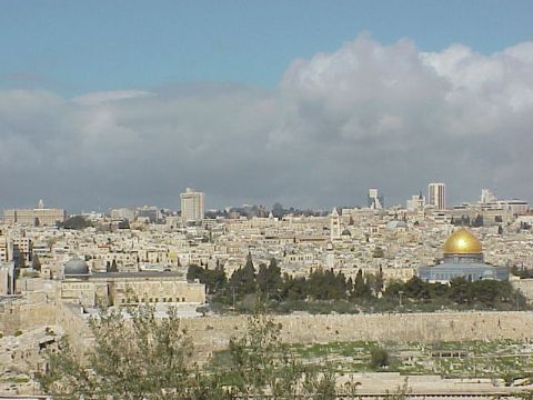


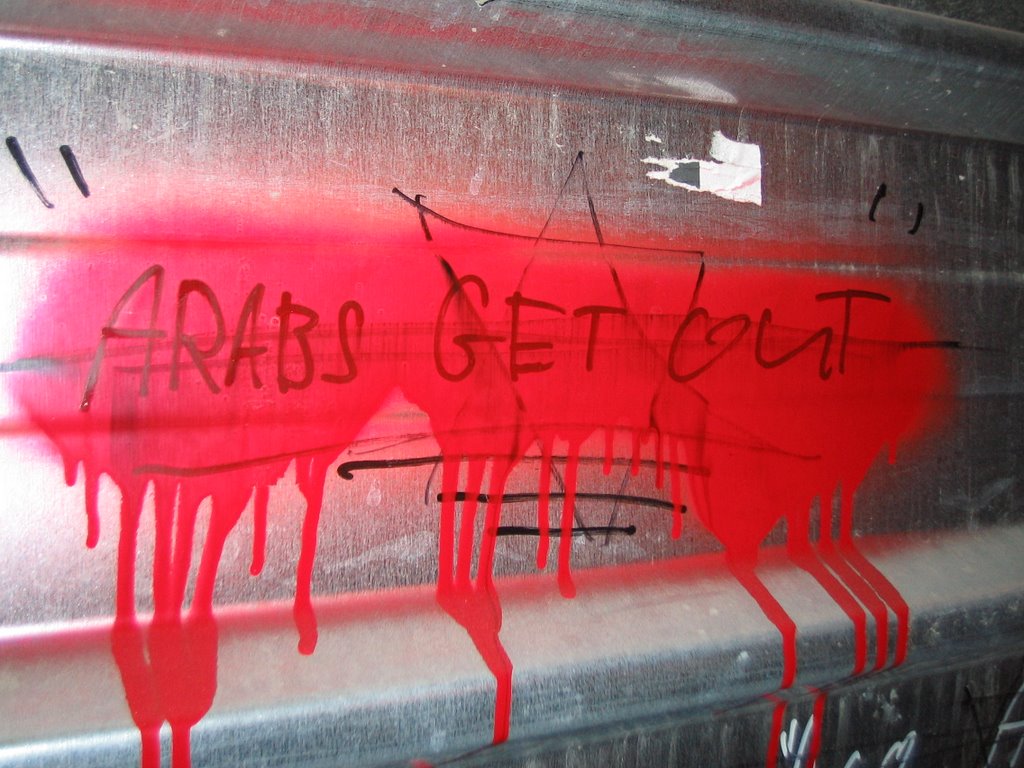
Evidence of the conflict over these sites is everywhere, in spray paint on the walls and in the security present around each site.